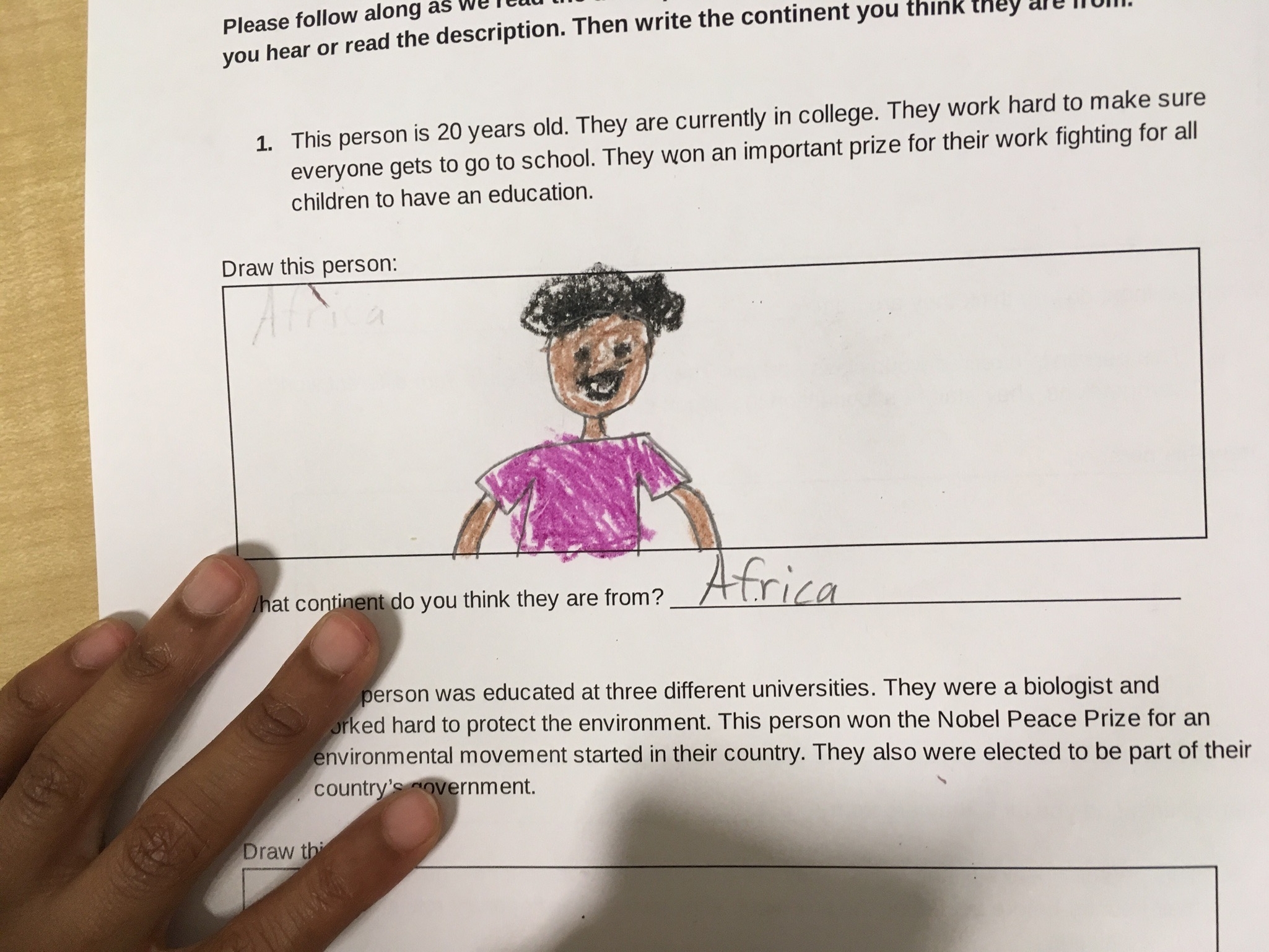
Teach Pluralism

Social Justice Educators

  • Home
  • About
  • Blog
  • What We Do
  • Past Workshops
  • Contact Us

Map Exploration

November 30, 2021 by Shardul Oza in curriculum

My 3rd graders and I have been learning all about maps! We learned about different features of maps, different kinds of maps, made our own maps (which were so creative) and more. This week, my co-teacher and I asked students to bring in a map from home. We told students it was their “homework” so they took the assignment very seriously, reporting talking to their parents to get permission and reporting back to us that they looked at different maps they found at home and decided not to bring in some that were too large or fragile etc.

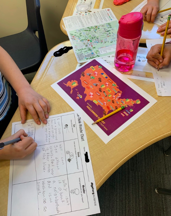
Once we all had maps at school (and we of course had some extra ones for students who forgot), we started our map exploration. First, as a class, we watched a Brainpop (not Brainpop Jr.) video about map skills and reviewed features of maps we might look for and reminded ourselves to use the map key or legend to help us understand the information the map was displaying. Then, we projected an image of this map of Washington, D.C. on the board. We let students have a minute to look at the map and see what they notice. Immediately, cries of, “Why is there so much white? It’s ALL white. There are so many white people!” filled the room. Students turned and talked about what they noticed and questions they had. 

They noticed so much. They had questions and observations about white neighborhoods taking over, why white and black neighborhoods are so separate, if it is like this everywhere, why there were so few (visible) Asian blocks, and what the gray areas meant (we explained those are areas where people don’t live because it’s Rock Creek Park or it might be a solely commercial district). Some students noted where our school might be and that it was in a white area as well. After giving students time for discussion and reflection, we passed out copies of these See, Think, Wonder sheets and told students to note one thing they discussed with their partner. 

Next, we gave each pair time to look at the maps they brought in and share with their partner. Students were very excited to share their maps! After they finished sharing and reflecting, they were free to walk around the classroom and look at other maps. We have a big world map on the wall and put out different books with maps in them as well such as My Map Book by Sara Fanelli and 50 Cities of the U.S.A.: Explore America’s Cities with 50 Fact-Filled Maps by Gabrielle Balkan. After students had time for (silent) exploration, they met in small groups (2-4 students per group) to discuss what they noticed, what questions they had, and anything they learned or wanted to learn more about next.

Eavesdropping on the discussion was fascinating! Students were surprised by the different types of maps and really wanted to explore more. One student had brought in a map of constellations, which really pushed us to think about maps as applying to everything, not just locations on Earth! Having students bring in the maps really led to strong investment and interest in the exploration as they wanted to share what they brought in and felt a personal role and connection. Starting with a map of DC also really intrigued students, as many of them were born in the area and have always lived here, so looking at DC in a new way really interested them. And of course, the questions and responses discussed (and a few responses included above) show how deeply they were thinking about who lives where and why that might be. Other maps that were really popular (that we provided) were this map showing each state’s favorite Halloween candy, this map showing ice cream consumption by state, and all the maps in My Map Book (linked above).

Subscribe to our blog:

Name *
Thank you!
November 30, 2021 /Shardul Oza
maps, geography, race, housing, DC, segregation, Social Studies
curriculum
Comment
From https://www.theatlantic.com/photo/2017/06/beauty-and-color-scenes-from-ethiopia/530166/

From https://www.theatlantic.com/photo/2017/06/beauty-and-color-scenes-from-ethiopia/530166/

Learning Through Photos

September 28, 2021 by Shardul Oza in curriculum

In my third grade class, we usually end our year with an integrated Social Studies, Reading, and Writing unit where we learn about the different regions of and research different countries in Africa, but this past year we ran out of time and weren’t able to do a lot of the creative grouping or sharing of materials that characterize this unit. So instead we focused on learning more about Ethiopia as a class. We chose Ethiopia as Washington D.C. is home to the largest population of Ethiopian born people in the United States. There are also many Ethiopian Americans in and around D.C. In past years, we’ve ordered food from a local Eritrean restaurant as part of our end of year celebration, but this year we were sadly unable to do that.

We started our study of Ethiopia by looking at maps, watching short videos, and reading nonfiction books and articles together. Students had so many questions and wanted to see more, so we gave them time to work in pairs and enjoy this photo essay about Ethiopia from The Atlantic: Beauty and Color: Scenes From Ethiopia (the first photo is the cover photo for this post).

Students looked at the essays on their individual laptops (we had one laptop per pair or group of three), although it can also work to look at each photo together as a whole class. We wanted them to have more autonomy to spend time with the photos that really interested them as well as have small group discussions (which are difficult when everyone is sitting at their own desk six feet apart). As they looked at the photos, we had them fill out a See Think Wonder chart which we found here (also pictured above).


IMG_0318.jpg

You can see one student’s work here. This student said he had more questions, but wasn’t sure how to write them down (phrase them) and also talked about them a lot with his group mates. We reminded students about the importance of being respectful if something is new or different for you and asked them for suggestions for what you could say in that situation (This is something new for me, this is different from what I’m used to, I notice, I used to think, but now I’m thinking..).

I learned this approach of having students research or gain information from photos from Tony Stead whom I was lucky enough to work with at a public school in NYC. He taught me so many new ways of approaching reading and writing nonfiction which I’ve used in Social Studies, Writing, and Reading lessons since. (This idea that I’m writing about would also work for Science, but I don’t teach Science in my current position as we have separate Science teachers/class at my school). Tony Stead has a different chart called a R.A.N. (Reading and Analyzing Nonfiction) chart that is a modified/improved version of a KWL chart (what you know, want to know, and what you’ve learned) that is also a wonderful tool for a longer research unit.

I’ve used this approach of looking at photos and observing, pondering, and wondering in many different ways. It’s also really helpful with current or historical events (we took a similar approach, but with a slightly different chart when learning about sit ins). Also, if you are interested in learning about the large Ethiopian population in and around Washington D.C., we loved this story by WAMU!

Subscribe to our blog:

Name *
Thank you!
September 28, 2021 /Shardul Oza
Social Studies, geography, inquiry, Ethiopia
curriculum
Comment
Participants’ drawings during our activity

Participants’ drawings during our activity

Capital Area Progressive Schools!

May 13, 2019 by Shardul Oza in conferences, simulations

Last month, I had the opportunity to present at the Capital Area Progressive Schools (CAPS) Conference! The theme of the conference was Responsive Practice: Diversity, Equity, and Differentiation. This conference takes place every two years and all CAPS members faculty and staff are invited to join. This year, my school had the day off for students so everyone could attend and it seemed like most other schools did so as well. It was so lovely that so many schools were able to do this so we had so many other teachers (and faculty and staff) to meet! Coming from a small school with only one class per grade, it’s always very exciting to have a chance to talk to other 3rd grade teachers.

My (new) co-teacher and I presented our What continent do you think they are from? drawing humans activity that Gabby and I designed as part of our 3rd grade geography curriculum. We use this activity to open our students’ eyes to the reality of the entire world out there (as opposed to only North America and maybe Europe) as well as their internalized biases (and of course, so much more!). We read a description of a human being, ask them to draw this human using only crayons, and then write down what continent they think this person is from.

This was only the second time I’ve done this activity with adults, and really enjoyed the discussion and questions from our audience. We had a smaller group than we anticipated so we were able to open up discussion as we went along and ask people to share out instead of only sharing in a small group. It was fascinating hearing about different thought processes and how, as adults, we become instantly aware of our implicit biases and what it felt like to try to challenge them.

We had a very interesting discussion about application or adaptation of this activity for pre-kindergarten aged students, interdisciplinary or subject specific use in middle school classrooms, and talked about Science applications and generally beginning the dismantling or challenging of stereotypes when starting a new unit of study. At our school, we’ve been fortunate to work closely with the Kindergarten and First Grade teachers who are engaging in social justice work in their classrooms as well, and were responsive to the needs we communicated based on the work we were doing in Fifth Grade, so we shared some of the activities they do as well.

One part of this activity that I really love is asking participants to write down what continent they think someone is from! Many of the adults at our workshop found that they were able to be mindful of their own first instincts around race or gender when drawing humans, but the continent twist surprised them and made them ask: why is it that we always think of Europeans and North Americans? What does this mean for our classrooms and the voices and faces we need to highlight?

unnamed-2.jpg unnamed.jpg

Later in the day, I went to a roundtable discussion about continuing diversity, equity, and inclusion work a few years in and how to keep moving after the initial momentum from starting out (as an institution or as staff/faculty at an institution. It was helpful hearing about work at other schools and problems, reactions and possible solutions that have come up.

Some of my other takeaways and valuable reminders included:

  • I love the idea of a cultural competency checklist as a place to start with all faculty and staff - it really underscores the idea that we all are commiting to this important work and all have something to bring or work on.

  • One school had everyone fill out an inventory detailing who they spend most of their time with, who their friends are, and who they are comfortable with as a concrete way for people to understand why certain spaces might feel more or less natural or customary for them

  • One share involved someone explaining that there was a wide disparity of how people were experiencing the school and different ways they tried to make people understand that

  • Progressive schools are grounded in relationships so everyone’s experience matters!


Subscribe to our blog:

Name *
Thank you!
May 13, 2019 /Shardul Oza
Capitol Area Progressive Schools, conferences, professional development, workshop, social justice education, geography
conferences, simulations
Comment
IMG_0139.jpg
IMG_0140.jpg
IMG_0141.jpg

What continent do you think they are from? Drawing humans to reveal internalized bias

November 13, 2017 by Shardul Oza in simulations

In the process of teaching (and learning) geography in our third grade classroom, we found that our students were very North America and Europe centric. While eight year olds are naturally egocentric, we wanted an activity to shift their perspectives and push them to realize that there are “real, important people” ALL OVER the world.

So we redesigned our beloved activity where we draw people to realize our internalized biases (that we wrote for 5th graders, but have used with adults as well) to make it more geography focused and 3rd grade appropriate. While we were focused on introducing inspiring (and unexpected) people from different continents, we also thought we might uncover some gender and racial biases along the way.

We have been learning about world geography starting with the seven continents and five oceans since the first week of school. We started with the continents and learning about the differences between a continent, country, state, and city in order to make sure that our students could be clear and accurate.

The Procedure

For this activity, we refreshed our memories by sharing some information about each continent as a whole group. Then, we had students work independently on what we called a puzzle. We gave them a handout with five descriptions of humans, a space to draw each human, and a line to write what continent they thought each human was from. We also gave them a bag of crayons to draw with. We’ve discovered that asking people to draw with crayons means they have to choose a color for their humans and often surprise themselves with the assumptions they make.

We read each description out loud and asked students to follow along on their paper. Then, we gave them two minutes to draw a person. We told them to draw “whomever you imagine in your head when you hear the description.” The descriptions lacked gender specific pronouns or any clues to age, race, or background. After they finished drawing, we told them to write an answer to the question, “What continent do you think this person is from?”

Some students happily drew whatever they imagined, including props, speech bubbles, and detailed accessories. Others were more hesitant and expressed concern about getting the answer wrong. In general, students found assigning a continent to a description of a person easier as they could copy down one of the seven continents so their choices were more concrete.

Revealing the Answers

In typical third grade fashion, some students were disappointed that they didn’t guess all of the continents correctly when we revealed the actual humans we had been describing at the end (and what continent and country they were from). But our students were also fascinated by hearing about new (and very inspiring) people, so they quickly moved on and realized that learning, thinking and understanding were far more important than getting “the right answer”. They also loved hearing what country each person was from.

We chose one person from Asia, Africa, South America, Europe, and Australia. Multiple students identified the person we described from Asia - Malala Yousafzai - from our description of her and wrote her name down next to their drawing of her. However, when we read our description of Sadiq Khan, which included the fact that he is a practicing Muslim, no one guessed that he was from Europe.

The person we described from South America was Michelle Bachelet (the current and first female president of Chile), which confused some of our students because we mentioned that she is the president of her country. One student asked how that was possible because there have only been boy presidents? We reminded her that this is true in the United States, but not in many other countries.

Students comparing responses and discussing their thinking process

Students comparing responses and discussing their thinking process

Many students were surprised that the Nobel Peace Prize winning scientist who studied at three different universities (Wangari Maathai) was an African women. Many students also thought most of the people were from North America or Europe (except for the person who is actually from Europe). We had one female student who drew only women, and one male student who drew only men. Another student drew androgynous people because she said she couldn’t tell from the descriptions and she didn’t want to make assumptions.

Debrief and Reflections

After we revealed the identities of each person described and discussed our reactions, questions, and comments about each person, we asked students to complete one or more of the following prompts.

While doing this activity...

I was surprised by..

I felt..

I learned…

I used to think… , but now I’m thinking …

Students shared out at the end, and had thoughtful reflections (see quotes from students’ reflections below). We love that they are embracing studying geography in a humanizing way and challenging the assumptions or stereotypes that they may have learned from Western centric media in the past.

Student quotes:

“I thought I would be right, but all of my answers were wrong, but I realized it was okay and they didn't all have to be right.”

“I felt uncomfortable because I didn’t want to get it wrong or offend anyone, but then I realized [after our discussion] that we make assumptions about people whenever we meet someone new.”

“One thing I learned was some things that some people do different things and they are actually really important, but aren't always recognized because we learn mostly about North Americans.”

“I learned don't judge people by what they look like or by first impressions.”


Subscribe to our blog:

Name *
Thank you!
November 13, 2017 /Shardul Oza
simulation, geography, Social Studies, social justice education, curriculum
simulations
Comment

Subscribe to our blog

Sign up with your email address to receive our new blog posts!

We respect your privacy.

Thank you!